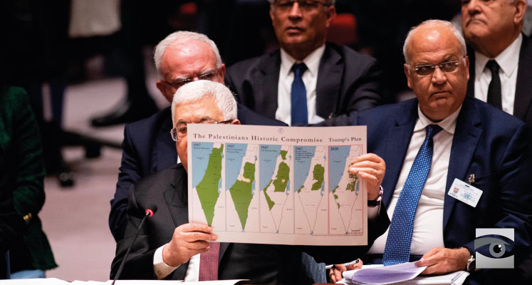

Palestinian president Mahmoud Abbas holds up a series of maps as he speaks to the UN Security Council on February 11, 2020. (Photo by JOHANNES EISELE/AFP via Getty Images)
Dov Lipman – Misleading Palestinian Maps Twist the Truth
re-post by permission of Dov Lipman-Honestreporting
Palestinian President Mahmoud Abbas appeared before the United Nations Security Council to protest President Trump’s proposed Middle East Peace Plan. Abbas held up a series of maps which he labeled “The Palestinian Historic Compromise.” They should have been labeled “The Misleading Palestinian Maps.”
People assume maps are accurate because they’re easy to accept at face value. But we often fail to consider their limitations and their ability to mislead. The ability of maps to convey three-dimensional realities on a two-dimensional sheet is more constrained than we realize. Titles, like headlines, frame the way we relate to the map. And when taken out of context, maps can be used to manipulate or deceive others.
Abbas’s Misleading Palestinian Maps
What Abbas sought to claim with his misleading Palestinian maps was that over the last 100 years, the Palestinians have been robbed of their land.
- The first map, labeled “1917,” showed the entire Land of Israel, between the Jordan River to Mediterranean Sea as green, suggesting that the entire land belonged to the Palestinians in what the map called “historic Palestine.”
- The second map, labeled “1937 Peel Commission Partition Plan,” showed all of southern Israel and most of central Israel as “Palestinian;” part of central Israel and all northern Israel were described as Jewish.
- The third map, labeled “1947 UN Partition Plan,” showed most of southern Israel, part of central Israel, and most of northern Israel as Jewish; most of central Israel and just a small part of the north and south as Palestinian.
- The fourth map, titled “1967 Border Lines Endorsed by the PLO in 1988 as a Historic Compromise for Peace,” showed most of the Holy Land as Jewish with just the West Bank and the Gaza Strip as Palestinian.
- The fifth and final map was dated 2020 with the words “Trump’s Plan” in large letters above it. It showed the Gaza Strip, small slivers of land in southern Israel, and pieces of the West Bank as Palestinian and the rest of Israel as Jewish.

What these maps failed to convey was one thing – the truth.
With that in mind, let’s take a look at the PA chief’s use of misleading Palestinian maps.
Map 1. From the River to the Sea
 In 1917, the entire area of what was called “Palestine” did not belong to any Arab entity. The land in those borders is actually the homeland of the Jewish people and thousands of years ago was “the Land of Israel.” The Romans ruthlessly exiled the Jews 2,000 years ago and called the entire land ”Palaestina” (a name which means “migratory” which had been given to a people who conquered the coastal Gaza area) in an attempt to remove any hint of Jewish connection to the land.
During the ensuing 2,000 years different empires took control of the land and by 1917 the land which evolved to be called “Palestine” shifted from the dissolving Ottoman Empire to the League of Nations. There were 600,000 Arabs and 60,000 Jews living in the region at the time. But the land was given to the British who called for the establishment of a Jewish state in its boundaries via the Balfour Declaration. All residents at the time were called “Palestinians.” There was no Arab state in the land at the time and there was no effort to establish an Arab state of any kind in the land.
Abbas used misleading Palestinian maps to portray the entire Holy Land as belonging to an Arab “Palestinian people” which was then robbed from them.
Map 2. The Peel Commission’s Proposal
 The Peel Commission was appointed by British authorities in 1936 to investigate Arab violence against the Jews and devise solutions.
The following year, the commission proposed dividing the land into two states – a Jewish one and an Arab one. The map is the one which Abbas showed – with the Arab side receiving most of the land and a population transfer to ensure that Jews lived in the Jewish state and Arabs in the Arab state.
Related reading: Did Arab Violence Really Start With the Occupation?
The Peel Commission also recommended a number of economic measures including the Jewish state providing financial assistance to the Arab state since most of the Arab income at that point came from Jewish employers. Jerusalem and a stretch of land reaching to the Mediterranean would remain under British control with international supervision.
Had the Arabs accepted this plan, they could be celebrating the 83rd anniversary of a large, independent Arab state alongside a small Jewish state.
But the Arab leadership rejected the Peel Commission’s proposals. Arab violence against the Jews continued.
Misleading Palestinian maps spin a false narrative of grievance. This specific map distorts a historic opportunity for the creation of a Palestinian state in most of the Holy Land . The Arabs pushed for all-or-nothing and failed.
Map 3. Distorting the UN Partition Plan
 Ten years of Arab violence against the Jews followed, leading to the British decision in February 1947 to end their Mandate for Palestine. London handed the problem over to the UN. The UN Special Committee on Palestine (UNSCOP) was created to determine what to do.
The committee returned with its recommendation in August: the UN Partition Plan.
Because the Jewish population had grown significantly in the decade since the Peel Commission, the UN Partition Plan proposed vastly different borders for the Jewish and Arab states. The Jewish state would include the Eastern Galilee, the coast from Haifa to Rehovot, and most of the Negev. The Arab state would include the central and western Galilee, Acre, the high ground of Judea and Samaria (now known as the West Bank), Jaffa, and the southern coast from north of Ashdod to the Egyptian border, including the Gaza Strip. Jerusalem would be placed under international control.
This plan’s proposed Arab state made up 43 percent of Palestine including all of the high ground (not counting Jerusalem), one-third of the coastline, and control of all the main aquifers.
The Jewish state made up 56% of the land mass, most of which was in the barren Negev desert, unsuitable for either urban or agricultural development. The Jewish state was given sole access to the Sea of Galilee which was crucial for its water supply.
While the plan did its best to best to separate between Jewish and Arab populations, there was going to be a large Arab minority in the Jewish state (45%), and an insignificant Jewish minority (a mere one percent) in the Arab state. The plan dictated that the Jewish and Arab minorities would become full-fledged citizens of the states in which they lived.
The Zionist leadership accepted the Partition Plan. The Arabs, however, rejected it, stating that they “concluded from a survey of Palestine history that Zionist claims to that country had no legal or moral basis.” They simply would not accept a Jewish state in the region and said outright that they would attack if the Jews attempted to establish a state with the goal of destroying it.
Again, we see misleading Palestinian maps sweep Arab rejection under the rug.
Related reading: How the UN Partition Led to Israel’s Birth
Map 4. The Green Line: Borders or Armistice Lines?
 This is the greatest of the misleading Palestinian maps. What Abbas calls the map of 1967 is in actuality the armistice lines Israel signed with Jordan and Egypt in 1949 after Israel’s War of Independence. In international law, armistice lines are not borders; they merely mark breaks in the fighting. So these were never internationally recognized borders. Jordan held onto the West Bank and Egypt controlled the Gaza Strip and Sinai Peninsula. Neither of these areas which Abbas labels as Palestinian were “Palestinian.”
In 1967, the Arab armies massed on Israel’s borders with the intent to attack and destroy the Jewish state. Egypt also closed the Straits of Tiran to Israeli shipping which was an act of war. Israel launched a successful preemptive strike on Egypt which led to all-out war with Egypt and Syria, which attacked from the north. Israel appealed to Jordan not to join the fighting from the east but Jordan attacked. Israel completely routed the Arabs. The Jordanian army fled to the eastern bank of the Jordan River. Egypt not only lost control of Gaza but the entire Sinai Peninsula. The Golan Heights, from which Syria shelled the Galilee, was in Israeli hands.
Immediately after the war, Israel offered to return the territories it captured in return for peace. The Arab response to Israel’s land for peace offer was known as the Three Noes:
- No peace with Israel.
- No recognition of Israel.
- No negotiations with Israel.

Israeli foreign minister Abba Eban
During the decade after the 1973 Yom Kippur War, the Palestinian leadership came around to accepting the basic land for peace formula. But there was a catch. The Palestinians insisted, among other demands, on having control of all of the land Israel captured during the Six-Day War, even though the borders were armistice lines and not international borders.
For Israel, however, those borders were not secure. Israeli foreign minister Abba Eban famously called the 1967 lines “Auschwitz borders,” explaining that the Jewish state would be unable to defend itself if Palestinians controlling the West Bank high ground attacked.
Mahmoud Abbas forgot to tell the Security Council a number of other things:
- The attempts Israel made to reach an agreement with the Palestinians at the 2000 Camp David II talks where Israel offered close to 100% of what the Palestinians sought — and which the Palestinians rejected.
- Israel’s Gaza disengagement in 2005.
- Ehud Olmert’s sweeping offers in 2008 which Abbas admitted he didn’t even reply to.
- Abbas refused to negotiate despite Israel’s 10-month moratorium on settlement activity, which the Palestinian leader demanded as a precondition for talks.
Misleading Palestinian maps can use the words “historic compromise” but historical facts filled with Palestinian rejections say otherwise.
Map 5. The US Peace Plan
 Abbas referred to President Donald Trump’s peace plan as “Swiss cheese” and displayed the map as a continuation of the Palestinians losing more and more land. But a closer analysis tells a different story.
It provides the Palestinians with the same amount of land they would have if they were given the entire West Bank – the “historic compromise” which Abbas said the Palestinian leadership had made. However, the plan gives the Jewish state what it needs to secure itself from the Palestinian state. But to make sure that the Palestinians would not lose land mass while Israel maintains what it needs for its security, the map gives the Palestinian land swaps in other areas.
The Palestinians not only rejected this plan but threatened that it would lead to further terror attacks against Israelis.
* * *
Individually, each of the maps Abbas presented require some historical context to be properly understood. But when taken together, the cumulative effect is to paint a skewed picture of a disintegrating Palestinian state.
Is it possible that the Palestinians blew opportunities for statehood in 1937, 1947, 1967, 2000, 2008, and now in 2020 because they refuse to accept the mere existence of a Jewish state?
The misleading Palestinian maps which Abbas presented to the Security Council and the truth behind their stories indicate that the answer to that question is an unfortunate yes.
 Rabbi Dov Lipman, HonestReporting’s Senior Manager – Community Outreach, was elected to the 19th Knesset in January 2013, making him the first American born MK in nearly 30 years. He rose to national and international prominence for his role in combating religious extremism in Bet Shemesh. The author of seven books about Judaism and Israel, Rabbi Lipman holds rabbinic ordination from Ner Israel Rabbinical College and a Masters in Education from Johns Hopkins University. He moved to Israel from Silver Spring, MD in July 2004 with his wife, Dena, and four children. Since 2015, former MK Lipman has been a columnist for the Jerusalem Post and Times of Israel, a political commentator for ILTV and i24 News, and has focused on Israel advocacy both in Israel and abroad.


