
Erez Speiser – The Sanhedrin Trail
Israel is blessed with several multi-day Hiking tracks. The Golan trail (125 Km), The Jesus trail (65 Km) and the world-famous Israel National Trail (INT), approximately 1,100 km long, named by National Geographic as one of the 20 best “epic hiking trails” in the world!!
On 22/April/2018 a new member formally joined this group: The Sanhedrin Trail.
The trail crosses the lower Galilee area following sites associated with the Sanhedrin. Although formally launched, the project is not finished yet, as I will highlight during this column.
The project is managed by the Israel Antiquities Authority. I have spoken with them recently to bring the most accurate information regarding the project’s status.
They were very cooperative, and I could feel their passion and dedication to the project.
The Sanhedrin was an assembly of seventy-one rabbis appointed to sit as a tribunal in the ancient Land of Israel. They began operating during the Second Temple period. Sanhedrin assembly met regularly in the Temple in Jerusalem. After the failure of the Bar Kokhba Revolt (136 CE), the Great Sanhedrin moved to the Galilee area and operated for almost 300 years in several locations across the lower Galilee, until 425 CE.
The new trail gives us a good mix of beautiful scenery and Jewish history of the period.
The trail is nicknamed by some as the three 70’s trail:
- Launched on Israel’s 70 birthday.
- Follows the 70 members of the Sanhedrin
- The trail is about 70 Km long
The Trails starts at Beit Shearim near Tivon and ends after about 70 Km in ancient Tiberias. The difficulty level is medium. The terrain is relatively easy, mostly on dirt roads and without any big climbs, but the daily hiking distances are not short and vary between 15 and 25 Km.
The trail is described by its creators as Israel’s first “Smart Trail”. The trail is accompanied by a mobile friendly website. The website has a live map that shows your actual location on the trail for easier and safer navigation. Each landmark along the trail has an information page that includes text information about the landmark. Some locations have in addition: Pictures, Voice guidance, riddles, Videos and in the future, augmented reality that is supposed to show a virtual reconstruction of heritage sites, integrate virtual guides for children along the route and bring to life prominent scholars.
The multi-media information is now limited only to a few landmarks, but it is continuously expanded with the target to finish everything until the end of 2018.
The website is only in Hebrew, but English is planned to be added in the future.

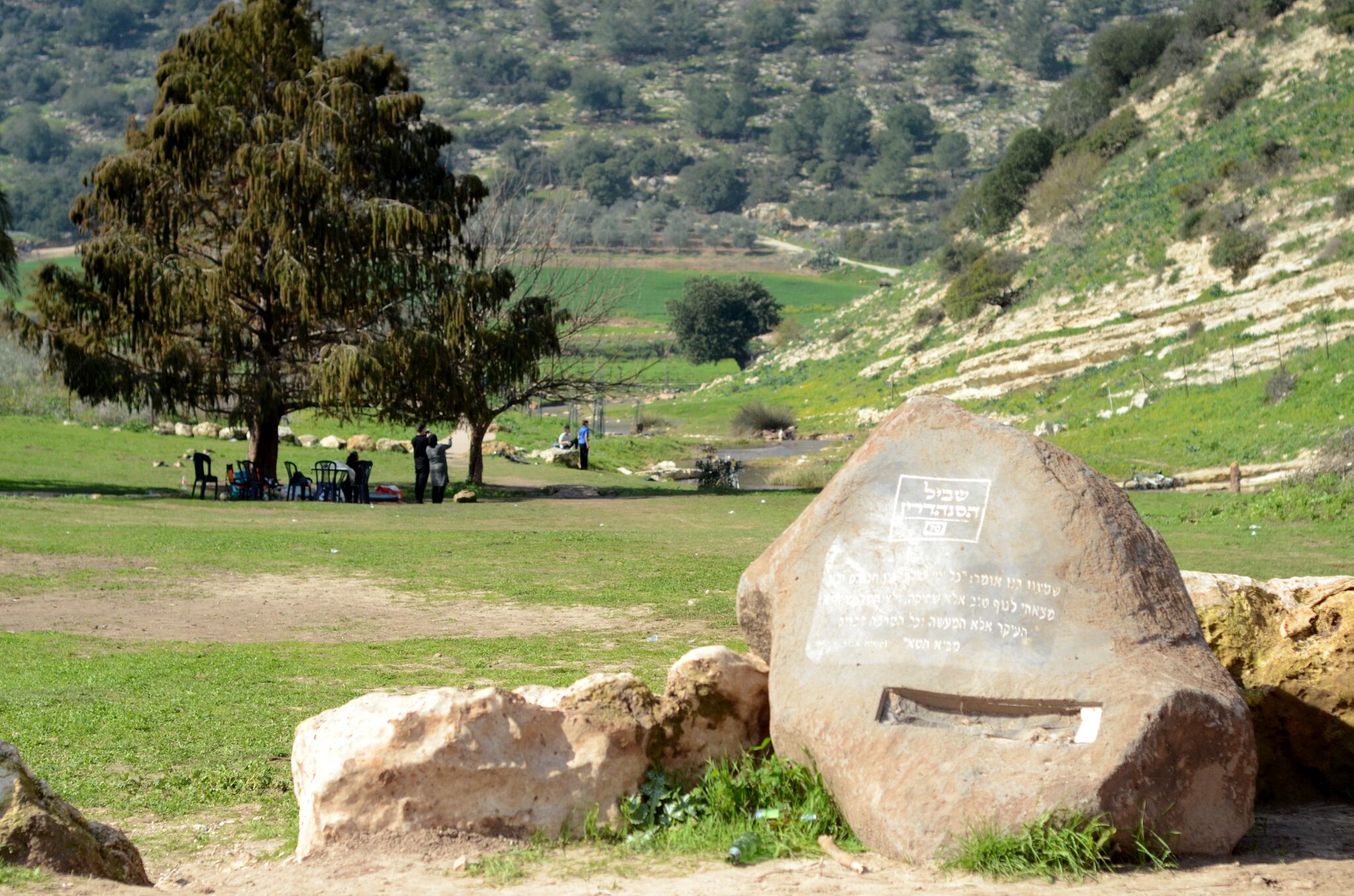
Smark-Stones.-Photo-By-Antiquities-Authority
The attractions along the trail are marked on decorated rocks that blend nicely to the surrounding nature and provide explanations about each site. They should also interact with the above-mentioned website.
The markers of the trail are also innovative:

- Green arrows – Pointing to the starting point & symbolize the Green scenery of the Galilee.
- Blue arrows – Pointing to the ending point & symbolize the strive to spiritualty.
- Red Menorah – Placed between the arrows and symbolizes Chazal and Sanhedrin
The way-marking of the full 70 Km is not complete yet. This again is aimed to be completed until the end of 2018.

3D Models of Tiberius Theatre. Photo by Jacob Shmidov
Trail itinerary and the main landmarks on each day:
Trail itinerary and the main landmarks on each day:
- Day 1 – From Beit Shearim to Ancient Usha:
- Beit Shearim National Park.
- Alexander Zaid Statue.
- Ancient Usha.
- Day 2 – From old Usha to Yodfat:
- Mount Atzmon.
- Ancient Yodfat.
- Day 3 – From Yodfat to Zipori:
- Rabi Yehuda H’anasi Tomb.
- Wadi Zipori.
- Ancient Ziporri National park.
- Day 4 – Zipori to Arbel:
- Zipori aqueduct.
- Karnei Hitim.
- Arbel ancient synagogue.
- Day 5 – Arbel to Tiberias:
- Great Views down to the sea of Galilee.
- Ancient Tiberias.
Each section or landmark can be done separately, making the project attractive to a wide range of people. Ranging from just a family visit to an archeological site up to an epic 5 days hiking track.

Ancient Tiberius. Photo By Antiquities Authority
In my opinion the project was launched pre-maturely. Too many things are still missing. Mainly full way-marking from start to finish, a decent map and additional languages on the website.
But I am sure that the good people of the Antiquities Authority that are deeply committed to the project, will get the job done in the foreseen future.

Young-students-on-the-trail.-Photo-By-Antiquities-Authority
However, we can enjoy some of the sections/landmarks already. The main recommendations for now are:
- Ancient Usha – a newly revealed archeological site.
- Ancient Tiberias – for this landmark the web site is in better form.
- The trail from Arbel to Tiberias is relatively better way-marked and provides great views down to the sea of Galilee.
I will revisit the issue towards the end of the year and update the post accordingly.
Related Links:
- Sanhedrin Trail official site. (Only in Hebrew)
- Additional Day Hikes in the Galilee.
- Learn more about the Sanhedrin.
- Beit Shearim
- Tiberias
- Karney Hattin
- ZIpori (Sepphoris)

-

- Map of the planned Sanhedrin Trail. Drafting by Anastasia Shapiro and Yair Amitzur/Israel Antiquities Authority
-

- High school students doing archaeological excavations to prepare the Sanhedrin Trail. Photo by Shmuel Magal/Israel Antiquities Authority.
-

- Ancient Tiberius. Photo By Antiquities Authority
-

- 3D Models of Tiberius Theatre. Photo by Jacob Shmidov
-

- Young-students-on-the-trail.-Photo-By-Antiquities-Authority
-

- Smark-Stones.-Photo-By-Antiquities-Authority


